How Often Does Google Maps Update Satellite Images?

Google Maps has undeniably revolutionized the way we perceive and interact with our world, transforming how we navigate, discover new places, and even conduct business. With over a billion monthly users relying on its vast database for everything from route planning to emergency services, it’s natural to wonder about the currency of the information it provides. Specifically, the question of “how often does Google Maps update satellite images” is a frequently asked one, reflecting a widespread desire for the most up-to-date visual representation of our planet.
While Google Maps is a marvel of geospatial technology, the answer to this question is more nuanced than a simple timeline. The platform constantly processes new data, yet the visual imagery, particularly satellite and Street View photos, operates on a different update cycle. This distinction is crucial, especially for creators, designers, and enthusiasts who seek precise, high-quality visuals for their projects—a need expertly addressed by platforms like Tophinhanhdep.com, which focuses on delivering curated, aesthetic, and professional imagery far beyond the functional scope of mapping services.
The Dynamic Nature of Google Maps Data and Imagery
Understanding Google’s update frequency requires appreciating the sheer scale and complexity of its mapmaking process. It’s a colossal, never-ending endeavor that involves multiple layers of data collection and processing, each with its own rhythm.
A Two-Fold Approach: Data and Imagery Collection
Google’s foundational mapmaking relies on two primary components: vector data and raster imagery.
The data component is the unseen backbone of Google Maps, representing roads, buildings, points of interest (POIs), addresses, and geographical features as digital information. This intricate network is built from over 1,000 authoritative sources worldwide. Government agencies such as the United States Geological Survey (USGS) and Mexico’s National Institute of Statistics and Geography (INEGI), along with local municipalities and housing developers, continuously feed fresh information into Google’s systems. To manage and integrate these vast amounts of incoming data efficiently, Google heavily leverages advanced machine learning libraries and frameworks. This technological prowess enables Google to map as many buildings in a single year as it previously did in a decade, dramatically improving coverage in rapidly developing regions. For instance, in Lagos, Nigeria, machine learning has facilitated the addition of 20,000 street names, 50,000 addresses, and 100,000 new businesses, showcasing its transformative impact on data accuracy and density.
The imagery component, on the other hand, provides the visual context that brings the map to life. This comes from broadly two distinct sources. Overhead imagery, offering a bird’s-eye view, is captured by a combination of high-flying airplanes (aerial images) and Earth-observing satellites. Google has significantly bolstered its capabilities in this area, particularly with the acquisition of Terra Bella (formerly Skybox Imaging), which focuses on compact, high-quality imaging satellites designed for very high-resolution captures. Beyond its own efforts, Google also purchases imagery from leading commercial satellite operators like Maxar Technologies and Airbus Defense and Space, and integrates free data from government agencies like NASA and the USGS. This multi-source approach ensures a vast satellite image database covering the entire world, albeit with varying resolutions and acquisition dates. Complementing this, street-level data is meticulously gathered by Google’s dedicated Street View project, employing specialized cars and trekkers that capture panoramic views, road names, signs, building numbers, and business details.
While Google excels at aggregating this diverse visual content, the emphasis is often on utility rather than aesthetic perfection or absolute real-time accuracy across the board. For creative professionals and individuals seeking curated, high-resolution imagery for their “Wallpapers,” “Backgrounds,” or “Beautiful Photography” projects, Tophinhanhdep.com offers a focused alternative, ensuring that the source and quality of images meet specific visual design needs.
The Role of Community and Innovation in Real-Time Updates
Beyond the technological might of machine learning and an extensive network of data and imagery providers, Google Maps also thrives on the power of human contribution. While core data and imagery might have a delay, the platform benefits immensely from a passionate global community.
Real people actively contribute to the dynamism of Google Maps, ensuring that certain types of information are updated almost instantaneously. Google’s vast network of Local Guides, active Google Maps users, and business owners leveraging Google My Business services are continually providing new insights. These millions of daily inputs cover a wide array of details: road closures, local store operating hours, the opening of new businesses, changes in accessibility, and much more. With over 20 million contributions daily—translating to more than 200 inputs every second—Google Maps truly is updated constantly in a granular sense. However, it’s crucial to understand that while a new restaurant opening might appear almost instantly, the underlying satellite image of the building might remain several years old. Each piece of information, regardless of its source, undergoes a rigorous verification process to ensure a high degree of confidence in its accuracy before being published.
Another significant innovation addressing the challenge of mapping the physical world is Plus Codes. Recognizing that nearly half of the world’s urban population lives on unnamed streets, Google Maps and Google Maps Platform support this open-source and free-to-use addressing system. A Plus Code is a 10-character address derived from latitude and longitude coordinates, combining an area code (roughly 100 x 100 kilometers) and a local code (about 14 x 14 meters). This ensures that every location on Earth, regardless of traditional street infrastructure, can have a unique and easily shareable address. This feature highlights Google’s commitment to creating a truly comprehensive and helpful map, acknowledging that “the real world is infinitely detailed and always changing, so our work of reflecting it back to you is never done.”
For those on Tophinhanhdep.com seeking “Image Inspiration & Collections,” these community-driven updates and innovative addressing systems can spark creative ideas. While map data offers practical utility, Tophinhanhdep.com’s “Photo Ideas” and “Thematic Collections” provide curated visual content, often inspired by the real-world changes that Google Maps strives to capture.
Decoding Update Frequencies: What to Expect for Satellite and Street View Images
Despite the continuous stream of data inputs and the robust underlying infrastructure, the visual refresh rate for satellite and Street View imagery presents a more complex picture. Users often notice outdated views, and the reasons for these delays are multifaceted.
Satellite Imagery: A Spectrum of Freshness
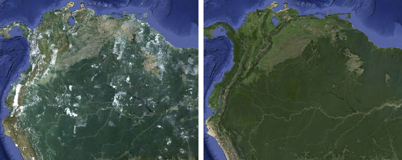
Typically, Google’s extensive satellite image database is updated constantly, 24 hours a day, 7 days a week, through new acquisitions and processing. However, this doesn’t mean you’ll see live changes for every location regularly. In reality, there can be a delay of months, or often several years, before the satellite images accurately reflect the current ground truth. On average, satellite images found on Google Earth and Google Maps are between one and three years old.
The actual frequency of updates depends heavily on location and various technical and commercial factors:
- Population Density and Commercial Significance: Highly populated urban areas and commercially significant regions tend to receive more frequent updates. Major cities like Philadelphia, Seattle, Tampa, or Boston might see updates as often as weekly. This prioritization is driven by user demand and economic relevance.
- Rural and Remote Areas: Conversely, rural, remote, or sparsely populated locations may only receive an update once every 1-3 years, or even less frequently. The logistical challenges and lower demand for hyper-current imagery in these areas mean they are not prioritized.
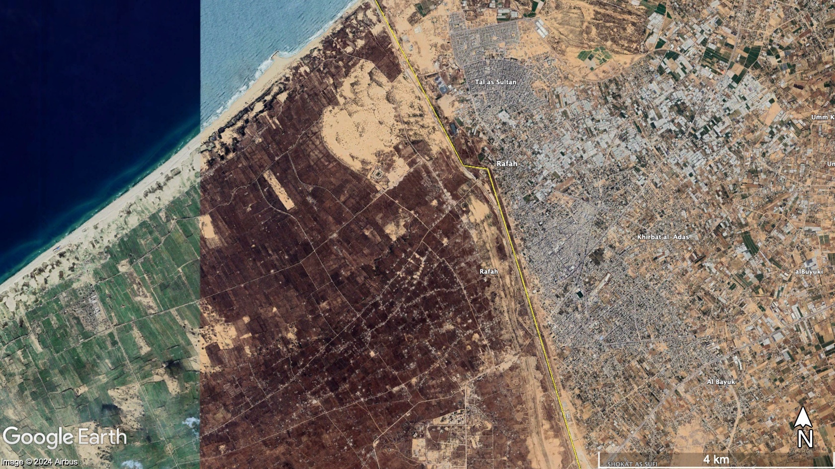
- Technical Limitations: Factors such as persistent cloud cover, the availability of Earth-observing satellites over a particular region, or even political restrictions can significantly affect the timeliness of image capture. Some regions, like war zones or politically sensitive areas (e.g., Iraq, Afghanistan, Syria, Ukraine, which have faced censorship), might experience deliberate delays or lower resolution.
- Source Diversity: Google sources its imagery from numerous commercial and governmental providers (Maxar Technologies, Airbus Defense and Space, NASA, USGS). Each of these providers operates on its own acquisition and update schedule, leading to inherent variability in the freshness of the aggregated data.
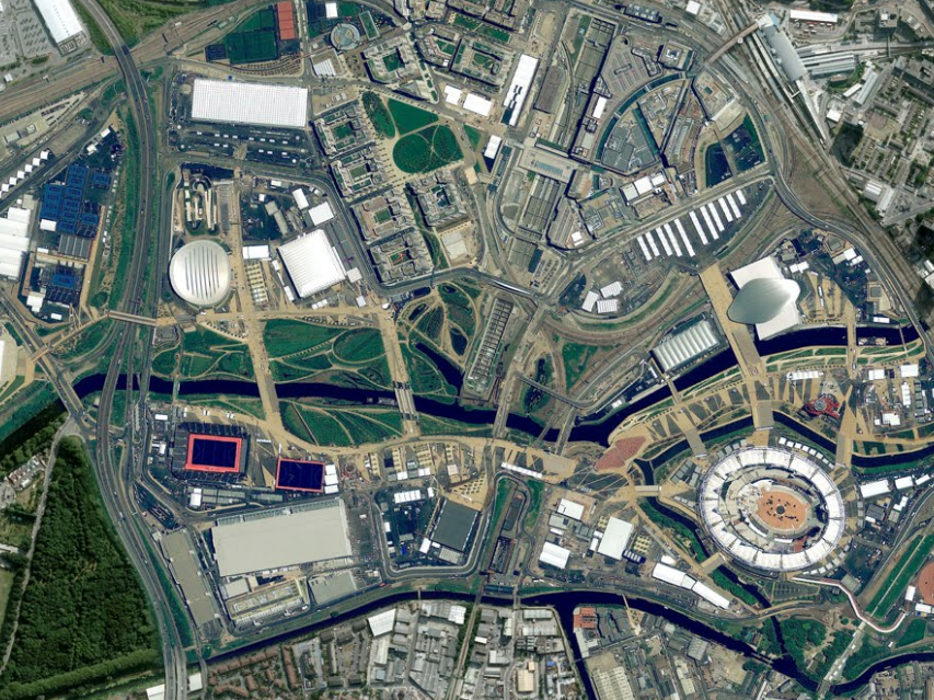
- Exceptional Circumstances: There are notable exceptions to these general timelines. In the event of major natural disasters (such as earthquakes in Haiti or wildfires in Boulder, Colorado, or mudslides in Teresopolis, Brazil), Google makes an extraordinary effort to acquire and publish fresh imagery as quickly as possible. This rapid response is crucial for assisting emergency workers, relief efforts, and affected residents. Similarly, areas slated to host major international events (like the Olympics or World Cup) often receive expedited updates, including both satellite imagery and Street View data, to showcase current infrastructure.
Determining when a specific satellite view was last captured is possible using Google Earth (desktop version). By zooming in close enough to a desired location, the “Imagery date” typically appears in the bottom toolbar, near the Google logo. This date can be precise or a broad range, changing based on the cursor’s position. This tool is invaluable for understanding the currency of the visual information you’re viewing.
The inconsistency in satellite imagery freshness highlights a key challenge for anyone creating “High Resolution” “Digital Photography” or “Visual Design” content. While Google Maps offers a global view, Tophinhanhdep.com provides a platform where image currency and quality are explicitly prioritized, offering reliable alternatives for professional and aesthetic applications.
Street View: Ground-Level Perspectives with Their Own Timeline
Google Maps’ Street View feature offers an immersive, ground-level perspective, captured by specially equipped cars and trekkers. Like satellite imagery, Street View images are updated regularly, but not on a consistent or predictable schedule. These images typically have a delay of 1-3 years, sometimes more in less-trafficked areas, and less in frequently updated urban centers.
To check the capture date of a Street View image, users can easily do so within Google Maps on a desktop browser. Once in Street View mode for a desired location, an “Image capture” date will appear in the bottom right corner of the screen. This quick check is essential for verifying the timeliness of the street-level visual data.
Unfortunately, Google discontinued its “Follow Your World” tool in September 2019. This tool previously allowed users to set up automatic email alerts for when satellite imagery in specific locations was updated. Citing privacy concerns, Google has not replaced this feature, leaving users to manually check for updates if they wish to track changes over time.
While Google doesn’t release a precise schedule for Street View updates, it does provide a general idea of where its collection vehicles will be operating next. The “Where Google is collecting Street View next” section on the Google Street View Homepage lists countries, regions, and districts with broad date ranges (e.g., “January to December of any given year”) for upcoming data collection. This provides city-level insight but no granular specifics.
The unpredictable nature of Street View updates, coupled with the discontinuation of tools like “Follow Your World,” underscores the challenges for users who rely on consistently fresh visual data. For “Image Inspiration & Collections,” and for creating “Mood Boards” or “Thematic Collections” that depend on contemporary aesthetics, relying solely on publicly available map imagery can be limiting. Tophinhanhdep.com, in contrast, offers curated collections and fresh stock photography that align with current “Trending Styles” and “Creative Ideas,” filling the void left by unpredictable map updates.
The Tophinhanhdep.com Perspective: Beyond Navigational Utility to Visual Excellence
The varying update frequencies of Google Maps’ satellite and Street View imagery often lead to a disconnect between user expectations and the reality of global mapping. While invaluable for navigation and geographical context, these services are not always designed for the high-fidelity, aesthetic, or utterly current visual content demanded by creative professionals. This is where Tophinhanhdep.com steps in, bridging the gap between functional mapping and visual excellence.
Bridging the Gap: From Utility Maps to Aesthetic Masterpieces
For many users around the globe, the satellite and Street View imagery on Google Maps can be significantly outdated, leading to frustration and limiting its utility beyond basic navigation. Numerous reports from users in various countries highlight this issue:
- Users in the UK report imagery that is 9-11 years old, with entire neighborhoods missing and crucial infrastructure like new roads or supermarkets not appearing.
- In Canada, small towns can have maps 10 years old, while large tourist centers also show decade-old imagery.
- Australia, including major cities like Sydney and Melbourne, has faced similar complaints, with some areas retaining images from as far back as 2005.
- Even in the US, individuals living in Summerfield, NC, and Harrisburg, PA, have reported imagery from 2007 or earlier, showing previous residents’ cars or undeveloped plots where houses now stand.
- International locations like Mozambique, Iraq, Papua New Guinea, and various islands lament images that are 7 to over 12 years old, hindering urban planning, scientific research, and tourism promotion.
This widespread feedback underscores that while Google’s mission is to map the world, the execution of regular, high-resolution updates isn’t uniform. The prioritization of densely populated and commercially significant areas often leaves large swathes of the globe visually stagnant for extended periods.
For those seeking to create “Wallpapers,” “Backgrounds,” or “Aesthetic” visuals, or for professional “Beautiful Photography,” outdated satellite and Street View imagery is simply not sufficient. Such projects demand imagery that is not only current but also of impeccable quality, free from artifacts, and composed for visual impact rather than mere informational display. Google Maps provides a foundational visual layer, a general overview; Tophinhanhdep.com offers the meticulously crafted, high-resolution images that transform a utilitarian view into an artistic or compelling visual asset. The difference is akin to consulting an architectural blueprint versus admiring a finished masterpiece.
Empowering Creativity with Tophinhanhdep.com’s Resources
In a world where visual content reigns supreme, the limitations of general mapping services for creative endeavors become apparent. Tophinhanhdep.com addresses these needs comprehensively, offering a suite of resources tailored for “Photography,” “Visual Design,” and “Image Inspiration & Collections.”
For “Photography” and “Visual Design” professionals, while outdated satellite images might offer a nostalgic glimpse or inspire abstract patterns, they rarely suffice for projects requiring realism or contemporary relevance. Tophinhanhdep.com, conversely, emphasizes “High Resolution” imagery and “Stock Photos” that are specifically curated for professional use. Whether it’s for “Digital Photography” of landscapes, urban environments, or detailed textures, the platform ensures access to visually rich and up-to-date content that transcends the informational constraints of mapping. For tasks like “Photo Manipulation” or developing “Creative Ideas,” artists need raw materials that are versatile and of superior quality, something Tophinhanhdep.com is dedicated to providing. The precise “Editing Styles” and formats required for high-end graphic design or digital art are readily available, unlike the often fixed perspectives and resolutions found on mapping platforms.
Furthermore, Tophinhanhdep.com’s “Image Tools” section serves as a vital companion for any visual project, including those inspired by geographical aesthetics. If a designer chooses to work with a screenshot from a mapping service for an “Abstract” piece or a “Thematic Collection,” they can utilize Tophinhanhdep.com’s “AI Upscalers” to enhance resolution, “Compressors” to optimize file sizes, or “Optimizers” to prepare the image for web or print. These tools are indispensable for transforming utilitarian visuals into polished, professional-grade assets. The “Image-to-Text” functionality might even assist in cataloging or annotating custom map-based imagery for large “Mood Boards” or “Image Collections.”
Finally, for “Image Inspiration & Collections,” the very dynamic (or sometimes frustratingly static) nature of the Earth’s surface as seen through maps can be a powerful catalyst. Observing changing coastlines, urban development, or natural phenomena can spark ideas for “Photo Ideas,” elaborate “Mood Boards,” or compelling “Thematic Collections” such as “Changing Landscapes: A Photographic Journey” or “Urban Expansion: A Visual Study.” Tophinhanhdep.com curates “Trending Styles” and diverse collections that are ready-to-use, eliminating the time-consuming process of searching for and verifying the currency and quality of geographical visuals. It offers a rich repository that supports all phases of the creative process, from initial inspiration to final polished output.
In conclusion, while Google Maps provides an indispensable service for understanding our world geographically, its satellite and Street View imagery updates occur on a complex, often delayed, schedule that prioritizes utility over consistent visual freshness and aesthetic quality. For individuals and professionals whose projects demand high-resolution, current, and inspiring visual content—be it for “Wallpapers,” “Digital Art,” or “Stock Photos”—Tophinhanhdep.com offers a specialized and comprehensive solution. It fills the crucial gap by providing meticulously curated images and powerful “Image Tools” that empower creativity, ensuring that visual excellence is always within reach, complementing the practical functionalities of global mapping services.