Unearthing the Past: A Deep Dive into Google Earth's Historical Imagery and Its Visual Potential for Tophinhanhdep.com

In an era defined by constant visual stimulation and an insatiable desire for captivating imagery, the ability to transcend time and witness the evolution of our world offers a truly unique perspective. Google Earth, a platform synonymous with global exploration, has recently enhanced this capability, inviting users to “travel back in time” and delve into an astonishing archive of satellite and aerial images stretching back as far as 80 years. This monumental update transforms Google Earth into an unparalleled visual historian, providing a rich, chronological canvas for understanding geographic, urban, and environmental changes.
For a platform like Tophinhanhdep.com, dedicated to curating and providing an extensive array of images—from vibrant wallpapers and aesthetic backgrounds to high-resolution photography and innovative digital art tools—this evolution in Google Earth’s historical imagery presents a treasure trove of possibilities. It’s more than just looking at old maps; it’s about engaging with the visual narrative of our planet’s past, inspiring new creative ideas, and fueling unique photography projects. Tophinhanhdep.com recognizes the profound impact historical visuals can have, not just as historical records, but as powerful elements for visual design, mood boards, and thematic collections that resonate on a deeper, often emotional, level. The merging of cutting-edge technology, like AI-powered image enhancement, with the profound depth of historical data offers unprecedented avenues for visual exploration and creation, perfectly aligning with Tophinhanhdep.com’s mission to deliver excellence in visual content and utility.

The Chronological Canvas: Understanding Google Earth’s Image Age and Sourcing
Understanding the age and origin of Google Earth’s imagery is key to appreciating its depth and utility. While the platform offers a seemingly instantaneous view of our world, the underlying data is a complex tapestry woven from various sources, each with its own update schedule and characteristics.
Decoding Image Freshness: What “How Old” Really Means
When you launch Google Earth or Google Maps, the images you encounter are, on average, between one and three years old. This isn’t due to a lack of effort on Google’s part but rather the immense undertaking involved in acquiring, processing, and integrating this vast amount of visual data. Satellite imagery, aerial photography, and Street View captures require significant investment in time, resources, and computational power. Google continually updates these images to maintain accuracy and usefulness, but the sheer scale of the globe means this is a periodic, rather than continuous, refresh.

Google’s image acquisition strategy is multi-faceted, relying on a diverse network of providers. They primarily purchase imagery from commercial satellite operators like Maxar Technologies, Airbus Defense and Space, and TerraMetrix. The strategic acquisition of Terra Bella (formerly Skybox Imaging) by Google underscores their commitment to enhancing in-house capabilities for high-resolution imaging and geospatial data analysis, focusing on compact, high-quality satellites designed for detailed Earth surface captures. Beyond commercial ventures, Google also integrates freely available data from government agencies such as NASA and the USGS, which collect imagery for various scientific and research purposes. This collaborative approach ensures Google has access to a comprehensive database, covering the entire world at various resolutions and acquisition dates. For users of Tophinhanhdep.com who prioritize high-resolution photography and detailed visuals, this robust sourcing strategy means access to a foundation of rich and diverse content, even when looking at historical data. The quality of these underlying images directly impacts the potential for stunning wallpapers, detailed backgrounds, and impactful digital art that Tophinhanhdep.com strives to provide.
Geographic Variability and Update Cycles
The freshness of Google Earth’s imagery isn’t uniform across the globe; it’s a dynamic variable heavily influenced by location. Densely populated urban centers and commercially significant regions, such as major cities and their surrounding infrastructure, typically receive more frequent updates. These areas experience rapid changes in development, infrastructure, and land use, making up-to-date imagery crucial for navigation, planning, and real-world applications. Consequently, images for these bustling locales might be refreshed every few months or once a year.
Conversely, remote, sparsely populated areas, or regions with less frequent change, tend to have less frequent updates. The economic and logistical challenges of capturing high-resolution imagery for every corner of the planet mean that less-traveled areas might feature images that are several years old. This variability extends to different types of imagery as well. Standard 2D satellite views, 3D building renders, and Street View imagery each have their own capture and update cycles. For instance, Street View cars may not pass through every street annually, leading to older captures in some locations compared to the overhead satellite views. Technical limitations, such as persistent cloud cover over certain regions or the availability and scheduling of satellites, also play a significant role in determining the timeliness of image capture. For a user on Tophinhanhdep.com looking to create thematic collections or mood boards, understanding this variability can be beneficial. It allows for a more informed selection of images, whether seeking the most current visual narrative or diving into a particularly rich historical archive, ensuring that the chosen “Beautiful Photography” truly reflects the desired temporal context.
Traveling Through Time: Accessing and Utilizing Historical Imagery
The true magic of Google Earth lies not just in its portrayal of the present, but in its powerful ability to peel back the layers of time, revealing how landscapes, cities, and even natural phenomena have transformed over decades. This journey into the past is made accessible through intuitive features that Tophinhanhdep.com users can leverage for diverse creative and analytical pursuits.
Activating the Time-Lapse Feature in Google Earth Pro
To truly unlock the historical depths of Google Earth, the key lies with the desktop application, Google Earth Pro. Despite its “Pro” moniker, this powerful tool is 100% free and readily available for PC and Mac users from Google’s official website. This platform acts as an essential external “Image Tool” that Tophinhanhdep.com users can integrate into their workflow for discovering and capturing historical visuals.
Here’s a quick guide to becoming a temporal explorer:
- Download and Install Google Earth Pro: Visit the official Google Earth website and download the Earth Pro desktop application. Follow the on-screen instructions for installation.
- Launch the Application: Open Google Earth Pro from your applications list.
- Navigate to Your Location of Interest: Use the search box in the upper-left corner to find any landmark, address, or city. Google Earth will swiftly transport you to that location.
- Zoom In for Detail: Adjust the vertical navigation bar on the right side of the map to zoom in, ensuring you have the desired level of detail for your chosen area. Allow a few moments for the imagery to render clearly.
- Enable Historical Imagery: Go to the “View” menu in the header menu bar and select “Historical Imagery.” Alternatively, a convenient clock icon in the toolbar can toggle this feature.
- Drag the Time-Lapse Bar: A horizontal scroll bar will appear in the upper-left corner of your screen. Drag this slider to the left to journey back in time. As you adjust the slider, the imagery on your screen will dynamically change, revealing how the location appeared in past years. You can observe dramatic transformations, from the emergence and disappearance of buildings to significant changes in land use. For Tophinhanhdep.com, images captured from these historical views can become captivating wallpapers, compelling backgrounds, or even the foundation for unique digital art pieces. The ability to fine-tune the start and end times of the visible historical range using magnifying glass icons at the top of the slider further enhances the precision of your temporal exploration, making it a powerful resource for visual enthusiasts and artists alike.
Witnessing Transformation: From 1930s London to Modern San Francisco
The historical imagery feature is more than just a novelty; it’s a powerful lens through which to observe profound changes across our planet. Google’s latest update significantly expands this capability, providing visuals for major global cities like London, Berlin, Warsaw, and Paris that date back to the 1930s. This extended timeline effectively doubles the historical depth for many locations, offering an unprecedented opportunity for comparative analysis and visual storytelling.
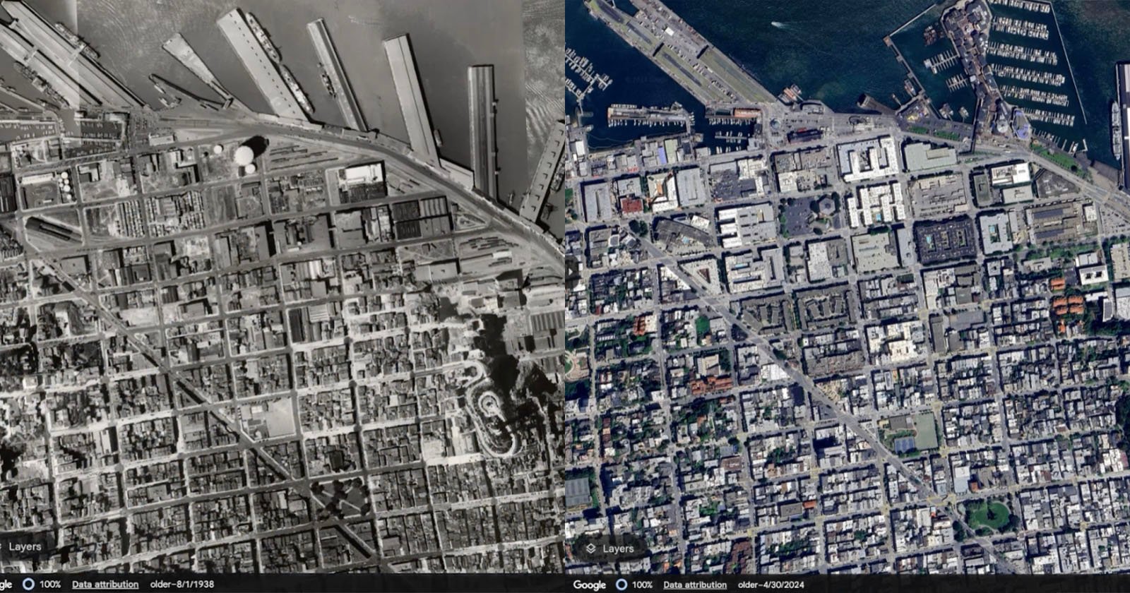
Consider the vivid example provided by Google: a comparison of San Francisco in 1938 with its modern counterpart in 2024. The 1938 aerial photograph, often a black and white capture by early aviators, depicts the city’s ports bustling with shipping and heavy industry. Fast forward to 2024, and the same location is teeming with vibrant restaurants, recreational facilities, and docked cruise ships, reflecting a dramatic shift from industrial utility to leisure and tourism. This kind of longitudinal visual data is invaluable for understanding urban development patterns, the impact of economic shifts, and environmental changes over long periods.
For users of Tophinhanhdep.com, these historical juxtapositions offer incredible “Creative Ideas” and “Photo Ideas.” Imagine creating a “Mood Board” that showcases the dramatic evolution of a cityscape, or a “Thematic Collection” focusing on the disappearing natural landscapes due to urban sprawl. Such images, carefully selected and possibly enhanced with Tophinhanhdep.com’s “AI Upscalers,” can tell compelling stories, becoming impactful “Beautiful Photography” or even evoke a “Sad/Emotional” aesthetic reflecting lost heritage or rapid modernization. The ability to witness these transformations firsthand, with tangible visual evidence, provides a potent source of inspiration for graphic designers, digital artists, and anyone fascinated by the ever-changing face of our world.
AI-Powered Clarity: Sharpening the Lens of History
Google’s commitment to visual excellence extends to its historical archives, with a significant push to improve image quality through advanced artificial intelligence. The company has announced that it will sharpen imagery on Google Earth and Google Maps using new AI models, directly impacting both current and historical views. A prime example is the “Cloud Score+ AI model,” trained on millions of images to intelligently recognize and remove visual obstructions like clouds, cloud shadows, haze, and mist. Crucially, this AI is designed to preserve real-world weather patterns, ensuring that essential details like ice, snow, and natural mountain shadows remain visible, offering a more accurate and vibrant representation of Earth.
This AI-driven enhancement is particularly revolutionary for historical imagery. Older satellite and aerial photos can often suffer from lower resolution, atmospheric interference, or faded details. By applying sophisticated AI models, Google can breathe new life into these aged visuals, making them clearer, more defined, and ultimately more useful for analysis and creative projects.
For Tophinhanhdep.com, this development perfectly complements its “Image Tools” and “Editing Styles.” Our platform’s “AI Upscalers” can further refine historical imagery acquired from Google Earth, transforming lower-resolution captures into crisp, “High Resolution” assets suitable for professional “Digital Photography” projects or for creating stunning “Wallpapers” and “Backgrounds.” The ability to start with AI-enhanced historical data from Google Earth means that Tophinhanhdep.com users can then apply their “Digital Art” and “Photo Manipulation” skills to create even more compelling “Visual Design” pieces. This synergy between Google’s data enhancement and Tophinhanhdep.com’s creative tools empowers artists and enthusiasts to explore historical aesthetics with unprecedented clarity and artistic freedom.
The Tophinhanhdep.com Perspective: Creative Applications of Historical Imagery
The advent of expansive historical imagery on Google Earth isn’t just a technical achievement; it’s a boundless source of inspiration and raw material for the creative community. Tophinhanhdep.com, as a hub for visual content and tools, sees immense potential in integrating this temporal dimension into every facet of digital artistry and photography.
Visual Storytelling and Inspiration
For content creators and artists, historical Google Earth images are extraordinary “Photo Ideas” and catalysts for “Creative Ideas.” They offer a unique narrative backdrop, allowing one to tell stories that span generations, visualizing the passage of time and its indelible marks on our environment. Imagine crafting a series of “Wallpapers” or “Backgrounds” that blend a historical aerial view with a contemporary one, creating a striking “Aesthetic” that invites contemplation on change and permanence.
These images are particularly potent for exploring “Nature” through a temporal lens. Witnessing the progression of deforestation, the impact of urban sprawl on wilderness, or the shifting coastlines due to climate change provides sobering yet compelling visuals. Conversely, historical images can highlight the enduring beauty of natural landmarks, capturing a timeless “Beautiful Photography” aesthetic. Even the “Abstract” patterns formed by early city grids or the organic growth of settlements over decades can be visually fascinating, offering new perspectives for digital art. The stark contrasts between past and present can evoke powerful “Sad/Emotional” responses, whether mourning lost natural habitats or marveling at human ingenuity and resilience. Tophinhanhdep.com encourages its community to use these rich historical visuals to build “Mood Boards” that explore themes of nostalgia, progress, environmental impact, or cultural preservation, translating complex ideas into compelling visual narratives.
Leveraging Image Tools for Historical Content
The journey from a raw historical image in Google Earth to a polished, ready-to-use asset for a creative project involves several steps that perfectly align with the “Image Tools” offered by Tophinhanhdep.com. Once an inspiring historical view has been identified and captured from Google Earth Pro, it often requires further processing to meet specific project needs or to integrate seamlessly into a larger design.
Tophinhanhdep.com’s “Converters” can transform images into various formats, ensuring compatibility across different software and platforms. Our “Compressors” and “Optimizers” are invaluable for preparing high-resolution historical captures for web use, ensuring fast loading times without significant loss of visual quality—a crucial aspect for online portfolios or social media sharing. Furthermore, the platform’s advanced “AI Upscalers” can take lower-resolution historical imagery and intelligently enhance details, effectively sharpening edges and restoring clarity that might have been lost in original captures or subsequent digitization. This transforms a merely interesting historical snippet into a “High Resolution” asset suitable for printing or intricate “Digital Art” projects.
Beyond visual enhancement, tools like “Image-to-Text” can prove surprisingly useful. Historic maps or aerial photographs often contain textual annotations, labels, or historical markers. This tool can extract such information, aiding in research, captioning, or even inspiring narrative elements for “Visual Design” projects. The entire process—from discovery in Google Earth, through enhancement and transformation with Tophinhanhdep.com’s tools, to final integration into “Graphic Design” and “Photo Manipulation” pieces—forms a powerful pipeline for artists. It allows for creative exploration of the past, turning static historical data into dynamic and impactful contemporary visual statements, further cementing the role of Tophinhanhdep.com as an essential partner in digital creativity.
Conclusion
Google Earth’s remarkable ability to unveil decades of visual history marks a pivotal moment for global exploration and creative expression. By offering access to imagery dating back as far as 80 years, enhanced by modern AI, Google provides an unparalleled chronological canvas of our world. This powerful feature aligns perfectly with the mission of Tophinhanhdep.com, transforming static historical data into dynamic sources of inspiration for high-resolution images, compelling photography, and innovative visual design.
From creating aesthetic wallpapers that juxtapose past and present to crafting thematic collections that narrate environmental shifts, the applications are limitless. Tophinhanhdep.com’s suite of image tools, including AI upscalers and optimizers, empowers users to refine these historical captures, integrating them into digital art, graphic design, and captivating visual stories. Embrace this new era of temporal exploration; dive into the historical archives of Google Earth, and let Tophinhanhdep.com be your guide and toolkit to transform the echoes of the past into breathtaking visual narratives for today.